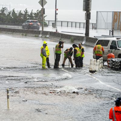
This month, the treacherous flash floods that inundated streets and gnarled bridges in New England, the tristate area, the Adirondacks, and Pennsylvania have served as a stark reminder — along with air-quality alerts, wildfires, and record heat — that the Northeast is hardly safe from the devastation caused by extreme weather events. In Vermont, historic flooding in parts of the state surpassed levels seen during 2011’s Tropical Storm Irene, but this time it wasn’t the result of a tropical storm — just a really, really wet 48 hours — and the kind of extreme precipitation event the Northeast will see a lot more of in the coming decades.
Jonathan Winter, an associate professor of geography at Dartmouth College, has co-authored two recent studies on extreme precipitation events in the Northeast, both documenting the rising number of such events in the Northeast over the past few decades and estimating how much more they’ll increase in the future. I talked to Winter about the implications of his research and the conversations about adaptation he’s having with local officials and farmers to help them prepare for the coming deluge.
What qualifies as an extreme precipitation event here in the Northeast?
We look at every wet day, so every day in which we experience rainfall or snowfall, and we rate them from largest to smallest. Then we take the top one percent and that becomes the threshold. When we look across the Northeast, on average that’s an event that has about 1.5 inches of liquid precipitation. The other way to think about it is that it’s basically the statistical once-per-year event.
In 2021, you published a study that examined the data on extreme precipitation in the Northeast between 1901 and 2014. How does that connect to the study you published in May?
If we’re trying to project 60 years into the future, the best way to do that is to start with the past observations, and there is a really clear increase in extreme precipitation in the recorded observations. The data from 1901 to 1995 shows steady extreme precipitation events — basically one event a year on average. Then, we saw a 50 percent increase post-1995. Based on that, we started looking at what’s causing that increase in extreme precipitation. What kind of storms are causing it? And then also thinking about the anthropogenic footprint. Is climate change causing an increase in extreme precipitation?
So what’s driving it?
Importantly, climate change increases the ability of the atmosphere to hold water vapor. You can think of the atmosphere like a bucket. Without climate change, say that bucket holds one gallon of water and, given the right conditions, that bucket dumps and creates an extreme precipitation event. Now, warm the atmosphere and the bucket gets bigger, holding maybe 1.5 gallons, and you get the same conditions that empty the bucket causing more frequent and larger extreme precipitation events.
And according to your research, we’ve seen a 50 percent increase in the number of the wettest days of the year since 1996 — and we’ll see another 52 percent increase by the end of the century.
That’s basically right. If anything, our predictions are a little conservative. We learn more as we go along. It’s an evolving science, but there’s no real disagreement in the data right now. If you look at a broad set of models, they’re all saying it’s getting wetter.
Will that mean a new wetter climate for the region, as far as overall rainfall?
It’s about a 10 percent increase in total rainfall, so the Northeast gets wetter. But because most of that increase is coming from the extremes, when you look at it over the entire year and average it out, it’s just a smaller increase. Still significant, but not nearly as big in terms of the numbers.
We saw what the recent flooding did in Vermont and New York. What other problems could arise?
The Vermont flooding is a good example to get us thinking about the worst-case scenario for extreme rainfall events and how flooding damages our infrastructure. We know what happens when we have flooding. We know it buckles roads and blows out culverts and ruins bridges. And we know it has the potential to kill. The Northeast is generally a pretty humid area already. As we get this wetting, an increase in both total rainfall and extreme precipitation, we might end up with farmers getting their crops damaged by flooding, and loss of accessibility to the fields. Those are the kinds of things I think about with my other branch of my work, which is Midwest agriculture. It may come to the Northeast and become problematic.
How should we respond? Can we?
We can divide our response to climate change into two different bins. The first is what we call mitigation, reducing greenhouse gas emissions. You can’t control the sky, so if you want to reduce the increase in extreme precipitation — that 50 percent increase — you’re going to have to reduce your greenhouse gas emissions. Plenty of people are working on that at the local, regional, and national levels.
Where my research is more useful is probably on the adaptation front. If, at the very least, we have this 50 percent increase in extreme precipitation baked into the cake already, the question is, what do we do? I’m starting to think more about how to meet with town managers or departments of transportation and help them figure out strategies for new design criteria for roads. Here’s the way we should size a culvert, or put in some green infrastructure to absorb some flood flow to leave areas natural so water, instead of flowing off pavement and concrete, can infiltrate soils. What kind of practices can we put in place for our farmers? Maybe vegetation strips where their fields meet streams so that less of their topsoil and the nutrients that they put on their fields wash into the stream. That’s where I’m trying to take my work now.
What kinds of reactions have you gotten from town managers?
They’re relatively open to it. Obviously, there’s a range of people who have opinions about whether this is anomalous, but I think we’ve seen enough incidents, and they’ve seen it, that there’s an openness to thinking through how we should replace that culvert or what the zoning map should be. They see that zoning maps are based on historical data, which is pretty dated.
Is there anything else you’re worrying about?
Something that’s been on my mind, especially with our last winter, is how our climate shifting will be an adjustment culturally. Being in New Hampshire, it’s a relatively cold place where we have these very clearly defined seasons of winter, mud, summer, and fall. New England and the Northeast, maybe more than other places that don’t have such distinct seasons, are defined by the climate. As that changes, those are the more intangible things that I think about.


